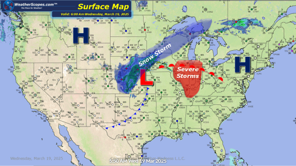
Today looks to be an active weather day. We have a system making its way across the Plains and into the Great Lakes today producing some severe weather out ahead of it and snow on the backend. Parts of IL, IN, MI, and WI will see some severe weather develop out ahead of the snow,... Continue Reading →
Daily Maps Tuesday March 18th, 2025
A nice day today for most of the US. Some cooler temps in the Northern Plains and parts of the Northeast with temps over getting to the mid 40's and 50's. Later tonight our storm system that will affect the Midwest and Great Lakes tomorrow will come out of The Rockies and bring some snow... Continue Reading →
Weekly Highlights March 16th to 22nd
This week we switch gears from the multiple days of severe weather we saw last week to snow. We are in an interesting weather pattern where we see mild weather and then these shots of cold weather. On Monday, in the Northern Plains a clipper will come through and produce 1-2’’ of snow. Wednesday, we will... Continue Reading →
Daily Maps Sunday March 16th, 2025
Today, still dealing with some severe weather as we have the past few days. Storms today are going through the Mid-Atlantic states, into Florida, and the Northeast. These storms will be gusty at times, and produce some heavy rainfall. The potential for some localized flooding will also be an issue. A tornado isn't out of... Continue Reading →
