Daily Maps Wednesday February 12th, 2025

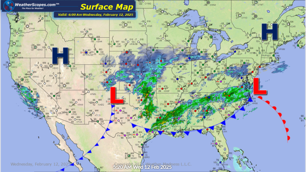
Our second snowstorm of the week is making its way through the Plains and Midwest. It will continue to move to the east and impact the Great Lakes and Northeast. Heaviest accumulations look to be 4-8'' for portions of Kansas to the Great Lakes and into the Northeast, and some areas of the interior areas... Continue Reading →

Daily Maps Tuesday February 11th, 2025

Some light lake effect snow this morning in the Great Lakes. Accumulations look to be a coating. We have our 1st snow storm of the week going through Kentucky and the Virginia's, making its way to the coast and the Baltimore area. The main accumulation for this storm will be 4-6'' with 1-4'' further north... Continue Reading →

Daily Maps Monday February 10th, 2025

Some cold arctic air coming down through the Plains and Great Lakes this morning and today. Some light snow showers across the Plains and Dakota's with accumulations of a coating to 2''. Some Lake Effect snow in parts of the Great Lakes and Northeast today. Accumulations look to be a coating to 2'' with the... Continue Reading →

Weekly Highlights February 9th to 15th

This week will be one for all the snow lovers. We will see 3 snow-storms affect most of the US. Tuesday into Wednesday, Friday into Saturday and Saturday into next Sunday will be the days where we will see rain, sleet, ice, snow, a chance at severe weather and some localized flooding. A busy week for... Continue Reading →

Website Powered by WordPress.com.

Up ↑