
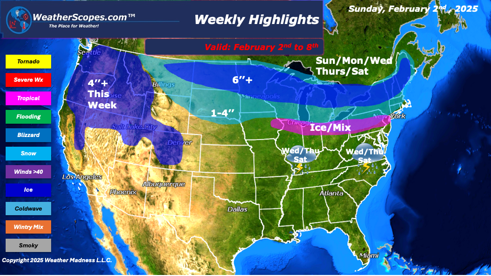
This week looks to be a messy one for many of us north of I-80. Multiple days this week we will deal with snow and clippers coming through the area bringing snow and ice. Sunday into Monday, a clipper will come through the Upper Great Lakes and into the Northeast. Then on Wednesday night into Thursday, another system will come through the Midwest into the Ohio Valley and the Northeast. That system will have rain to the south along the Tennessee Valley and Mid-Atlantic states, some ice through parts of the Midwest, Ohio Valley, and Northeast, and snow to the north in the Upper Great Lakes and interior areas of the Northeast.
On Saturday into next Sunday, parts of the Midwest into the Northeast will see another system with snow and ice to the north and rain to the south come through. The systems in the middle of the week and to end the week will almost be identical to the areas affected. Total accumulations for the week will be 1-4’’ for parts of the Midwest into the Northeast, while areas further north will see a decent amount of snow this week 6’’+ and some areas seeing almost 10’’ in the Upper Great Lakes and interior areas of the Northeast. The Southeast will see rain throughout the week with these systems coming through, with some areas seeing 1-2’’ of rain.
The Pacific NW and Rockies will see some significant snowfall this week as well as the Sierra Nevada’s. Most areas will see 4’’+ with higher amounts the further up in elevation.
By Matt K.
Meteorologist In-Training

Leave a comment