Daily Maps Friday April 4th, 2025

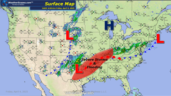
Another day with severe weather and heavy rainfall. Storms already breaking out across Kansas and Oklahoma this morning. More storms will develop later today in Texas. This will continue as this system moves to the Northeast producing more severe weather across the Mississippi and Tennessee Valleys. Hail, gusty conditions, and tornadoes are all possible with... Continue Reading →

Daily Maps Thursday April 3rd, 2025

Severe weather and heavy rains continue in the Mississippi Valley into the Tennessee Valley and parts of Texas and Oklahoma today. These storms are already producing tornadoes this morning and will continue to throughout the day. Hail and damaging winds will also be associated with this storms as it just stalls out over the area.... Continue Reading →

Daily Maps Wednesday April 2nd, 2025

A busy weather day today. Storms have already developed in the Plains overnight and currently. They produced a few tornadoes in Kansas. Those storms will continue in the Midwest down into the Mississippi and Ohio Valley today. Severe weather and tornadoes will be prevalent today. Gusty winds, hail, and heavy rain will also be associated... Continue Reading →

Severe Weather Wednesday April 2nd, 2025

Tomorrow looks to be quite the severe weather event. The SPC has highlighted a large area of the Mississippi Valley into the Ohio Valley as a place where severe weather will be prevalent. As you look at the HRRR resolution radar images you can see how massive these storms will be. The updraft helicity (measures... Continue Reading →

Website Powered by WordPress.com.

Up ↑