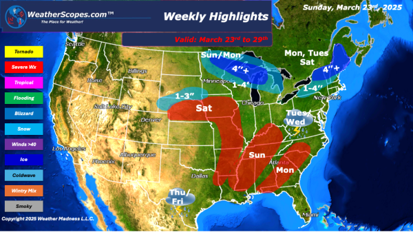
This week we start and end the week with some severe weather and snow. To kick things off a clipper will come down through the Upper Great Lakes on Sunday and making its way to the Northeast on Monday. Accumulations look to be around 1-4’’ with some areas further north seeing over 4’’. Monday, for parts... Continue Reading →
Daily Maps Sunday March 23rd, 2025
A clipper will come through the Upper Great Lakes today and into tonight, leaving some snow in its path. Accumulations look to be around 1-4'' with some areas further north seeing over 4''. The Plains, Midwest, Great Lakes, and parts of the Mississippi Valley will see some gusty conditions throughout the day, 30-40mph winds. Some... Continue Reading →
Daily Maps Saturday March 22nd, 2025
Some rain coming through parts of the Great Lakes into the Ohio Valley and Northeast this morning and afternoon. That rain will turn into snow for parts of the Northeast later today into tomorrow. Accumulations look to be a coating to a 1'' or 2''. Snow in the Rockies today. A pretty nice Saturday for... Continue Reading →
Daily Maps Friday March 21st, 2025
Overall a nice day today for most of the US. Some cooler temps in the Plains and Great Lakes today. Snow and rain in the Pacific NW today. Some rain and snow showers moving through the Northeast today, through parts of NY to Maine. Accumulations look to be around a coating to 2”.
