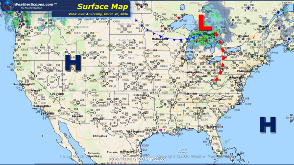
Weekly Highlights December 14th to 20th

This week’s weather pattern across the United States will show some notable temperature swings and several storm systems impacting different regions. Cold, brutal Arctic air will begin the week across the Plains, Midwest, Great Lakes, and Northeast. Temperatures in these areas will remain well below seasonal averages, reinforcing winter-like conditions and areas seeing single digit... Continue Reading →

Daily Maps Sunday December 14th, 2025

This morning, we are seeing some snow showers across portions of the Northeast from Maine to Philadelphia. Some light accumulations today mixed with some rain as well further south through the Mid-Atlantic states. Brutal cold across the Plains and Midwest this morning with temps in the single digits and some areas seeing temps below zero.... Continue Reading →

Daily Maps Saturday December 13th, 2025

A clipper coming through the Plains, Midwest, and Northeast today bringing some widespread snowfall. Accumulations look to be around 1-4'', with certain areas in central Iowa, Illinois, Indiana, Ohio, and Pennsylvania seeing over 4''. The DC area could also see some snow totals over 4''. Lake-effect snow will also impact the Northeast today as well.... Continue Reading →

Daily Maps Friday December 12th, 2025

This morning we are seeing some snow across the Virginia's and along the North Carolina border. Accumulations will be light with a coating to 1''. Later today more clippers will come through the Plains, Midwest, Great Lakes and the Northeast tomorrow. Accumulations will be around 1-4'', with some areas only seeing a coating. The Plains... Continue Reading →

Website Powered by WordPress.com.

Up ↑