Daily Maps Tuesday April 28th, 2026

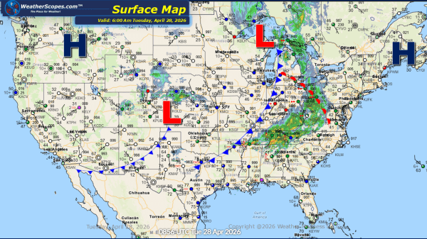
This morning, showers and thunderstorms are extending from the Northeast through the Mid-Atlantic and into the Southeast. Farther west, northern Texas is experiencing isolated thunderstorms, some of which have already reached severe levels, prompting warnings as they move through the region. Additional rainfall is also developing across parts of the Plains, contributing to an already... Continue Reading →
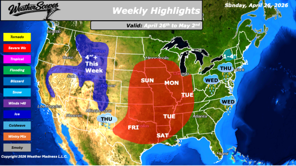
Weekly Highlights April 26th to May 2nd

This week’s weather will focus a dynamic system that will drive conditions beginning Sunday, when severe weather is expected to develop across the Plains. This threat will shift into the Midwest on Monday, where all hazards will be in play, including a heightened risk for tornadoes. By Tuesday, the focus for strong to severe storms... Continue Reading →

Daily Maps Saturday April 25th, 2026

This morning, we are seeing showers across portions of the Northeast, the Plains, and the Gulf Coast states. As the day progresses, another round of severe weather is expected to develop across the Plains and southern Plains, with the greatest focus on Oklahoma and Texas. Oklahoma, in particular, has experienced multiple rounds of severe weather... Continue Reading →

Daily Maps Thursday April 23rd, 2026

This morning, rain showers are moving through Minnesota and portions of the Northern Plains. In Montana and Wyoming, gusty conditions are expected to persist throughout the day, with wind gusts reaching up to 50 mph. As we head into tonight and into tomorrow, a more organized line of showers and thunderstorms is expected to take... Continue Reading →

Website Powered by WordPress.com.

Up ↑