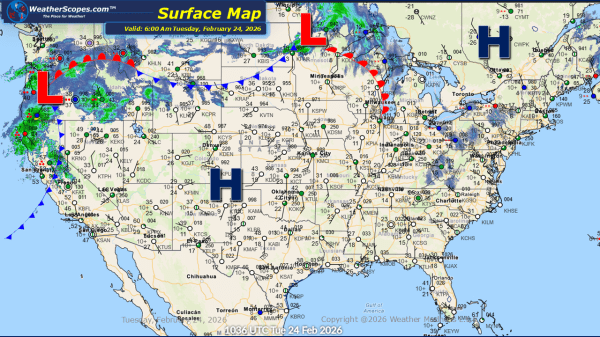
Daily Maps Tuesday February 3rd, 2026

This morning, we are seeing a clipper come through the Ohio and Tennessee Valley. We will see another clipper later today come through parts of the Northeast. Accumulations look to be a coating to 4'' , with the heavier totals across the Ohio Valley into the Appalachians. The Southeast will see some showers come through... Continue Reading →

Weekly Highlights February 1st to 7th

This week’s weather pattern will be active across much of the northern and eastern United States, driven by a series of fast-moving clipper systems. The first clipper will move through the Plains on Sunday before tracking across the Great Lakes and into the Northeast by Monday, bringing periods of light snow and reinforcing colder air.... Continue Reading →

Daily Maps Sunday February 1st, 2026

This morning, a clipper system is moving through the Plains and is expected to track into the Upper Great Lakes later tonight into tomorrow. Snow accumulations look to be around a coating up to 3 inches in some areas. The remnants of the system that produced snow across the Carolinas is moving offshore but continues... Continue Reading →

Daily Maps Friday January 30th, 2026

This morning, light snow is occurring across the Plains, with accumulations ranging from a light coating up to 1 inch. Lake-effect snow will once again impact the Great Lakes region today, with the heaviest accumulations expected in the Upper Peninsula of Michigan, the Buffalo area, and southeastern Wisconsin into the Chicago metro area. Most locations... Continue Reading →

Website Powered by WordPress.com.

Up ↑