
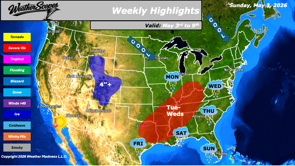
This week, we are seeing an overall pattern that brings warm, moist air northward from the Gulf while cooler air pushes in from Canada, creating a persistent battleground across the central United States. This contrast in air masses will serve as a catalyst for increasing storm development as the week progresses, with multiple rounds of active weather expected. The week begins with showers and thunderstorms across southern Florida on Sunday, producing periods of heavy rain and lightning. By Monday morning, this activity shifts into the Midwest, where a broader area of showers and thunderstorms is expected to develop, setting the stage for a more active midweek period.
From Tuesday into Wednesday, storm coverage expands across the Midwest and Mississippi Valley, with some storms likely becoming severe. Damaging winds, heavy rainfall, and isolated severe weather threats will extend into the Ohio Valley as well. At the same time, additional storm development is expected to push eastward into the Mid-Atlantic states, continuing the unsettled pattern. In the west, colder conditions aloft will bring snow to the higher elevations of the Rockies Tuesday night into Wednesday. The Denver metro area will see accumulating snowfall as well with areas seeing 1-4’’. By Thursday, cooler temperatures settle into the Great Lakes and Northeast, reinforcing the divide between the cooler northern tier and the warmer southern regions. Meanwhile, warm and dry conditions will dominate the Southwest, with southern California into the Phoenix area experiencing temperatures climbing into the 90s.
Toward the end of the week, attention turns to the southern Plains and Gulf Coast. On Friday and Saturday, another round of potentially severe storms could develop from southern Texas across the Gulf states, fueled by continued warmth and moisture in place. In addition to precipitation and storm threats, several regions including the Plains, Midwest, Southwest, and Northeast will experience periods of gusty winds throughout the week. With repeated rounds of rainfall expected across the Midwest, Mississippi Valley, and into portions of the Tennessee and Ohio Valleys, flooding concerns will need to be closely monitored.
By Matt K.
Forecaster

Leave a comment