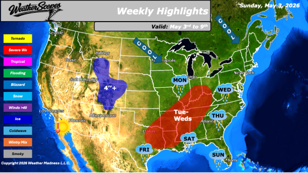
Daily Maps Tuesday April 14th, 2026

This morning, showers and thunderstorms are currently moving through portions of the Midwest and Ohio Valley, with these storms to continue tracking eastward into the Northeast throughout the day. As these storms progress, some may become severe, bringing the potential for strong winds, heavy rainfall, and isolated severe impacts. Attention then turns back to the... Continue Reading →

Weekly Highlights April 13th to 18th

This week’s weather pattern across the United States is shaping up to be active and, at times, hazardous, with multiple regions experiencing a variety of impactful conditions. Severe weather is expected to break out across Minnesota and into northern Wisconsin on Monday. Heavy rainfall, large hail, and gusty winds will be possible throughout the day.... Continue Reading →

Daily Maps Monday April 13th, 2026

This morning, showers are moving through portions of the Northeast, while additional precipitation is occurring across parts of the Pacific Northwest. In the northern Rockies, colder conditions will support snowfall in the higher elevations throughout the day. Attention then shifts to the Upper Midwest, where conditions are expected to become increasingly favorable for severe weather... Continue Reading →

Daily Maps Saturday April 11th, 2026

This morning, we are seeing showers across parts of the Midwest, along with additional precipitation moving through the Pacific Northwest. The showers in the Midwest are expected to gradually shift northward throughout the day, impacting areas across Wisconsin and Minnesota by the afternoon hours. Meanwhile, a broad swath of the western United States extending into... Continue Reading →

Website Powered by WordPress.com.

Up ↑